


When Cape Cod maps stopped naming us
We grew beyond personal

Forty years ago I was in Jerusalem having lunch at the home of Eran Laor.
Given the overwhelming tragedy of this moment, conjuring up that visit is like looking into a deep pool, a reminiscence of a long-ago time — though the connections to now, as if traced on a map across time, are direct.
He was a banker in Geneva at the end of World War Two, part of an international underground spiriting (some might say smuggling) valuables out of liberated German concentration camps into Palestine, converting assets that became a dowry to found and fund the State of Israel -- funneling refugees as well. My father had been involved and that’s why Mr. Laor invited me.
“Laor” in Hebrew could be translated as “to the light,” so given his activities I assumed this was a pseudonym. I never asked, and can’t confirm because both he and my dad are long gone. Now I wish I could ask them about their perspectives on this horrifying moment, which surely would be complicated, painful, and deeper even than the pool into which I’m looking.
Eran Laor also was among the world’s great map collectors, especially of Jerusalem which he described as “the navel of the world,” the bellybutton where the cosmic umbilical cord had been attached (and severed).
“Would you like to see an interesting map?” he asked. He moved to the far end of the living room, instructed me to push chairs out of the way, kneeled and began unfurling a scroll about two feet wide. It ran the entire room, maybe 30 feet.
“This map,” he said, “was created by cartographers advancing ahead of the army of the Roman Empire as it marched across Europe. It begins here in Jerusalem and ends in what is now France. That is why it is so long. The reason it is so narrow is that this army marched generally west. It did not explore much north or south. So here you have it.”
He taught me that maps are meant to be exact renditions of what is, but always fall short. They define what we know, or better put what we think we know and what we think we need to know. But they never are complete, never truly accurate, shaped by values, interests, and blinders.
And they always offer fascinating insights beyond geography.
OK, this is “A Cape Cod Voice,” so I’ll bring it home:
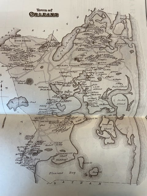
There have been many maps of this place drawn since the Colonial era, mainly to accomplish the European-rooted culture’s obsession – define property ownership. There also are nautical and highway maps to chart safe routes, fanciful bird’s-eye village views to profit from civic pride.
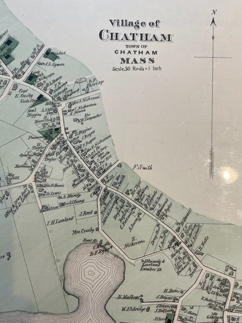
When you look at roads traced and railroad tracks stitched, intricate coves and necks along twisting shorelines, you also see dots or rectangles. These show houses with exact perimeters, additions and barns. Each is tagged with the name of the owner.
This was true of the great 1910 “Atlas of Barnstable County” created by Walker Lithographers and Publishing, a later generation of their amazing 1880 atlas. Readily apparent is how much of the Cape was owned by families with familiar names -- Nickerson, Crowell, Eldridge (and Eldredge), Atwood, Mayo, Freeman, Crocker, Hinckley.
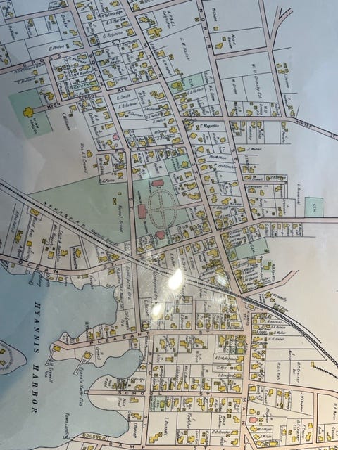
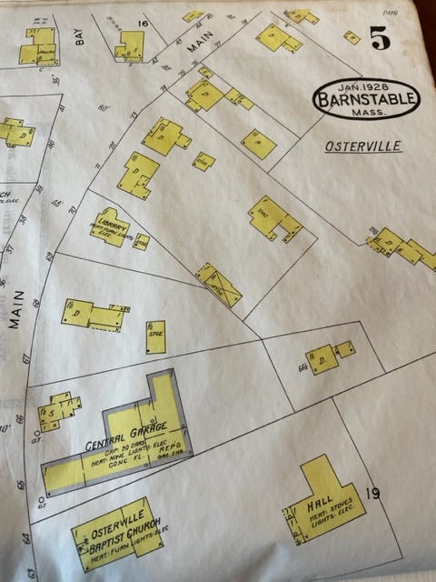
But by 1920, that personal practice came to an end; maps no longer included names. Homes and commercial properties were still delineated, but not by family.
Cape Cod had arrived at a fulcrum moment:
· There were too many properties to record individualized detail. Fledgling subdivisions, for example, couldn’t be defined lot by lot, though valiant mapmakers tried for awhile.
· The tradition of multiple generations owning and maintaining the same homestead was breaking down; defining a structure by family often became an inaccurate anachronism.
So our maps became impersonal, suggesting major cultural, social and economic change.
Fast forward:
Maps on parchment or paper that delineate a community are gone. Surveyors record lots in the Registry of Deeds electronically, while satellites can tell you if a neighbor moved your fence post (and whether their car is in the driveway). If you need to travel, punch the destination into a cellphone, no struggling with origami-folded paper in the glovebox.
We’re a long way from the demands of an advancing Roman army, a long way from Gaza where maps no longer apply, also far from how Cape Cod towns once portrayed themselves.
So maps, better put lack thereof, become one more indication of how our sense of self — and our place in this world — continues to morph.
(With thanks to Sturgis Library in Barnstable for access to a wonderful map and atlas collection, among many treasures.)
Haven’t subscribed yet? With all due respect, why not? Make it possible to see a Voice (a cool trick) — support good reporting, strong perspectives, unique Cape Cod takes every week. All that for far less than a cup of coffee. Please subscribe, it’s easy:
Seth, I am always fascinated by ancient maps, particularly those of where we live, but also far away places. As well, I miss the time that I had a road atlas in my car so that I could get an overview of a route or an area. Certainly GPS makes it more efficient to move from place to place, but it lacks that element of deeper knowledge about where you are going and the areas through which you might pass. Your story about Laor and your father deserves its own (or several) articles or even a book.
EXCELLENT! Would like to hear more about your Dad.
LOVED “ inaccurate anachronism!” Say that 5 times fast.
Manny